In spite of this mastery of the forest environment, the communities of Woteva in Fako Division, and Tinto, and Akwen / Agborkem in Manyu Division, all in the Southwest of Cameroon, live adjacent to a dense forest. Unfortunately, management of the forest resources have always been a problem. Much of the forest resources are untapped; those exploited are unevenly distributed.
The Environment and Rural Development Foundation (ERuDeF) recently launched the “participatory mapping “, a model of conservation wherein communities adjacent to forest areas take active part in the management of their forest resources. The model is also instrumental in the DRYAD project, which is geared towards promoting the development of local businesses from the extraction of Non-Timber Forest Products (NTFPs) from the community forests.
The participative approach engages villagers in the mapping of community forests with the help of a facilitator. The mapping process involves ground mapping, the collection of data, processing and the establishment of a concise map. At the level of the ground mapping, the villagers draw the space of their community forest on the ground by indicating the position of all elements including roads, rivers, non-timber forest products (NTFP) among others. Thereafter, they transfer the map got on the ground to the spreadsheet with all the details.
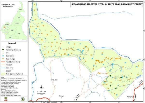
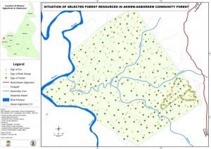
It was within this framework that the GIS specialist of the Environment and Rural Development Foundation (ERuDeF), Mr Dogmo Eugne, carried out Maps production, based on identification of forest resources of Tinto in the Upper Bayang Subdivision, Akwen and Agborkem in the Eyumojock Subdivision all in Manyu Division of Southwest Cameroon. Five resources, Bush mango (Irvingiagabonesis), Eru (Gnetumafricana), Bush pepper (Piper nigrum), timbers and Njansang ( Ricinodendronhendelotti), were selected to represent in the map.
In each community, at least three (03) local cartographers were trained on maps productionwith emphasis on the production of the ground mapping.
In Tinto, the local cartographers collected more than 300 points in their community forest while in Akwen and Agborkem, the local cartographers collected more than 200 points. The maps of the community forests have been produced and validated by the villagers of those communities with the facilitation of the GIS specialist from ERuDeF.
Now, the villagers acquired supplementary knowledge to reproduce and to update the map of resources in their forest area. By the end of the process, it was realized that the resources are dense in the different community forests.Taking the case of bush mango for example, the quantities are very important. In the community forest of Tinto, the number of stems of bush mango is estimated at 2500 stemsand more whereas in the one of Akwen-Agborkem, the number of stems of bush mango is estimated at 12000 stems and more.