Background Information
The coastal and marine ecosystem of Cameroon
Cameroon’s coastal and marine environment is located within the Gulf of Guinea. The coastal environment of Cameroon is opened to the Atlantic Ocean with a coastline of about 402km (Sayer et al, 1992). This coastline extends from 2° 20’ N at the Equatorial Guinea borders to 4° 40’ N at the Nigeria borders. It is located between Longitudes 8°151 E and 9° 30E. The coastline here is defined as the area extends from low tide mark to 60 km hinterland and to 200 nautical mile limits offshore. The continental shelf is about 10.600km2 with an Exclusive Economic zone (EEZ) of about 15,400km2. All aquatic ecosystems of this coastal plain of the Atlantic are covered within these limits, notably: ocean, coastal forests, deltas, sand dunes, mangroves, coastal rivers, estuaries, bays, lakes, beaches muddy coasts. The total drainage river basin is about 2.7 x 10⁵ km2 with the Sanaga contributing the highest sediment load (2.8 x 10² km3 / year). The limits of the coastal environment start from the high tide mark up to 60km inland. The continental limit is illustrated by a hypothetical line drawn from the north to the south which passes through: Mundemba, Muyuka, Dibombari, Edea and Nyambessan. This line passes through the national provinces of South West, Littoral and South. The coastal climate is characterized by monsoon winds of the Guinea type, predominantly south-westerly. These winds cause humidity values to be almost always at saturation point. Wind speeds attain exceptional values of 18 m/s (April 1993). In general, average wind speeds recorded over period of 10years (1983 –1993) vary between 0.5 and 2 m/s (Sayer et al, 1992).
Marine Biodiversity
The diversity of marine fish in Cameroon marine and coastal waters totals some 557 species, including 51 endemic species, 43 threatened, 59 reef associated, 131 pelagic, and 187 deep water. (http://www.fishbase.org/). 11 major fish families have been identified within Cameroon waters together with Shrimps, Cephalopods, Sharks and Rays of which two (Serranidae and Scombridae) are known to possess threatened fauna. (Krakstad et al, 2006). However, a total of 20 species have been documented as vulnerable, endangered, near threatened, critically endangered or data deficient and likely to occur in Cameroon waters. (www.IUCNREDList.org; Fish Base http://www.fishbase.org/, Chiambeng, 2006. These are listed in the table below with their common names and status.
Fish species likely to occur in Cameroon waters
(Source: NBSAP, 2012)
| Fish species | Common Name | Status |
| Family Rhincodontidae Rhincodon typus | Whale shark | Vulnerable |
| Family Lamnidae Carcharodon carcharias (Linnaeus, 1758) Isurus oxyrinchus Rafinesque, 1810 | Mackerel sharks or white sharks | Vulnerable Near threatened |
| Family Odontaspididae Carcharias taurus Rafinesque, 1810 | Sand tigers | Vulnerable |
| Family Carchahinidae Carcharhinus limbatus (Muller & Henle, 1839) | Requiem sharks | Vulnerable |
| Family Centrophoridae Centrophorus granulosus (Bloch & Schneider, 1801) | Vulnerable | |
| Family Dalatiidae Dalatias licha(Bonnaterre, 1788) | Sleeper sharks | Data deficient |
| Family Pristidae Pristis microdon Latham, 1794 Pristis pectinata Latham, 1794 Pristis pristis (Linnaeus, 1758) | Saw fishes | Endangered Endangered Critically Endangered |
| Family Myliobatidae Aetobatus narinari ( Euphrasen, 1790) | Eagle and Manta rays | Data deficient |
| Family Syngnathidae Hippocampus hippocampus (Linnaeus, 1758) | Pipefishes and Sea horses | Vulnerable |
| Family Gobiidae Bathygobius burtoni (O’ Shaughnessy, 1875) | (Gobies) known from Victoria | Data deficient |
| Family Scombridae Thunnus alalunga ( Bonnaterre, 1788) Thunnus obessus (Lowe, 1839) | Mackerels, Tunas | Data deficient Vulnerable |
| Family Serranidae Epinephelus itajara(Geofrey St Hilaire, 1809) Epinephelus marginatus Myctoroperca rubra | Sea basses, Groupers Dusky Grouper Mottled grouper | Critically endangered Endangered Data defficient |
| Family Xanthidae Xiphas glagius | Sword fish | Data deficient |
| Family latimeridae Latimera chalumnae. | West Indian Ocean coelacanth | Critically Endangered |
Cetaceans
Some twenty four species have been documented herein as likely to occur with the Cameroon coast of which, 8 species have been identified in recent studies including IUCN listed Atlantic Hump-backed Dolphin Sousa tseuzii (vulnerable) and the Humpback.
Table 2: List of Cetaceans species identified together with those likely to occur in Cameroon waters and their IUCN status
| Scientific name | Common Name | IUCN Status |
| Family Delphinidae | ||
| Stenella frontalis | Atlantic spotted Dolphin | Data Deficient |
| Stenella clymene | Data Deficient | Data Deficient |
| Sousa teuszii | Atlantic Hump-backed Dolphin | Vulnerable |
| Delphinus delphis | Atlantic Dolphin | Least Concern |
| Delphinus capensis | Long snouted common dolphin | Data Deficient |
| Delphinus capensis | Long snouted common dolphin | Data Deficient |
| Tursiops truncates | Common bottle nose dolphin | Least Concern |
| Stenella coeruleo alba | Stripped dolphin | Least Concern |
| Grampus griseus | Risso’s dolphin | Least Concern |
| Steno bredanensis | Rough-toughed dolphin | Least Concern |
| Stenella longirostris | Spinner dolphin | Data Deficient |
| Stenella atenuata | Pantropical spotted dolphin | Least Concern |
| Lagenodelphis hosei | Frasers dolphin | Least Concern |
| Pseudorca crassidens | False killer whale | Data Deficient |
| Orcinus orca | Killer whale | Data Deficient |
| Globicephala macrorhyncus | Short finned pilot whale | Data Deficient |
| Feresa attenuate | Pygmy killer whale D | Data Deficient |
| Peponocephala electra | Melon-headed whale | Least Concern |
| Family Zipihiidae | ||
| Mesoplodon europaeus | Mesoplodon europaeus | Data Deficient |
| Family Balaenopteridae | ||
| Balaenoptera borealis | Sei Whale | Endangered |
| Balaenoptera physalus | Fin Whale | Endangered |
| Eubalaena glacialis | Atlantic Right Whale | Endangered |
| Megaptera novaeangliae | Humpback Whale | Vulnerable EN |
| Family Physeteridae | ||
| Physeter macrocephalus | Large head Sperm | Vulnerable |
| Family Phoeconidae | ||
| Phoecoena phoecoena | Harbor purpoise | Least Concern |
Marine turtles
A total of four species have been identified as occurring within the project zone and its environs. Dermochelys coriacea, Lepidochelys olivacea, Chelonia mydas, and Eretmochelys imbricate all of which are in the IUCN red list.
Marine turtle species within Cameroon coast and their conservation status
| Scientific Name | Common Name | Status |
| Chelonia mydas | Atlantic Green turtle | Endangered |
| Eretmochelys imbricate | Hawksbill | Critically endangered |
| Dermochelys coriacea | Leatherback | Critically endangered |
| Lepidochelys olivacea | Olive Ridley | Vulnerable |
Aquatic mammals: The African manatee (Trichechus senegalensis) and Cameroon Clawless Otter are important aquatic mammals within the mangrove habitats and abundant in Douala-Edea Wildlife Reserve.
Mangrove ecosystem
In Cameroon, mangrove ecosystems are composed of six indigenous species, namely Rhizophora racemosa, Rhizophora harrisonii, Rhizophora mangle (Rhizophoraceae), Avicennia germinans (Avicenniaceae), Laguncularia racemosa, and Conocarpus erecrus (Combretaceae), as well as one exotic species Nypa fructicans (Arecaceae) (UNEP, 2007; Ajonina 2008). The mangroves are found in three areas, in particular:
- The Rio Del Rey (100 000 ha), in the north between the Njangassa area and the Nigerian border covering all the islands of the Rio Del Rey estuary.
- The estuary of Cameroon (88 000 ha), which extends from the mouth of the Sanaga River to Cape Bimbia where it cohabits with other systems such as river mangrove and estuary mangrove along the Wouri, Sanaga and Dibamba rivers (in the Littoral).
- The Ntem estuary (2 000 ha), which lies at the mouths of the following rivers: Nyong, Lokoundjé and Ntem in the South region.
Cameroon’s mangrove area (UNEP, 2007) dropped from about 272 000 ha in 1980 to about 195 000 ha in 2005 (a reduction of about 30 percent over a period of 25 years, or 2 500 ha/year of mangrove loss). Some mangrove pockets in Cameroon are still relatively untouched and the most important can be found in the Rio Del Rey Estuary, the Cameroon estuary and smaller estuaries of the mouths of the Sanaga, Lokoundjé and Ntem rivers.
While the Gulf of Guinea is not considered as one of the “world’s biodiversity hotspots”, the Rio Del Rey mangrove, which represents half (50 percent) of Cameroon’s mangrove and 10 percent of West Africa’s mangrove, is one of the last largely intact mangrove ecosystems along the West and Central African coast (FAO, 2018). In addition, the Douala-Edéa Nature Reserve (including the peripheral area) is considered a unique complex of coastal vegetation with a wide variety of habitat types, including giant mangroves along the coast measuring up to 100 cm in diameter and over 50 m high, wooded sand dunes, freshwater swamps, lakes and some giant forests on yellow clay soils. The resources of the mangrove ecosystems give rise to economic, social and demographic pressure. Indeed, the challenges relating to mangrove conservation in Cameroon are many: on the one hand, these ecosystems constitute a source of livelihood for the communities using these resources to feed themselves, generate income or reside (access to land); on the other hand, these ecosystems are subject to pressure from economic actors through urban expansion, agro-industrial development, the development of port activities, exploration and exploitation of hydrocarbons.
Mangroves of the Cameroon coast still have enormous potentials, despite the destruction of about one third of their total area. They cover 2,700km2 (Valet, 1973) and serve several purposes such as:
- Mangrove trees constitute excellent shelter for shrimps, mollusks, fishes and frogs etc.
- Substrate for periphyton consumed by animals.
- Aquaculture and eco-touristic sites.
- Nursery zone for fish and other aquatic animals
The red mangrove trees which are the most widespread species in Cameroon (90% of mangrove area) have very interesting properties which make them very useful (fire wood, construction of canoes, paddles and houses, production of latex for construction of nets, etc…). This species of wood can also be used for sculpture.
Fresh Water Ecosystems
The total extent of fresh water in Cameroon is about 3960 km2 (MINEPIA 1997) distributed in rivers, swamps, lakes and dams. Cameroon has a dense network of rivers, most of which arise on the Adamawa plateau and flow north or south. There are five main hydrological basins in Cameroon. These are; the Sanaga, Congo, Niger (Bénoué), Chad and Coastal basins. Lakes also constitute important surface water bodies in Cameroon. These lakes range from natural lakes (resulting mostly from volcanic activities e.g. Lake Nyos, Barombi etc.) to man-made lakes like the Yaoundé municipal lake.
State of Fauna
The fauna of this ecosystem comprise mainly: aquatic bentic fauna, mammals, Birds, reptiles, amphibians, fish, crustaceans and gastropods.
Benthic fauna: This is poorly documented except in the semi-arid ecosystem, where Lake Tchad has been found to host 3 groups of benthic macro-invertebrates comprising Worms, Molluscs and Insects.(Leveques et al, 1979).We find 5 families and 24 species of insects (Chironomides dominant (12 species), Tanypodinae (4sp), and the rest Orthocladiinae, Ephérnéroptères, Trichoptères); 3 families of Oligochaetes and 6 species dominated by the Naididae (4 species), with the Tubificidae (2species), and Alluroididae (1 species) and 2 groups of molluscs and 10 species dominated by Lamellibranches (7 species), followed by Prosobranches (3 species).
Mammals: Trichechus senegalensis (African Manatee) occurs in all the river basins, (Benouè and Kebbi Rivers, the Lake Chad Basin, Sanaga and Nyong Rivers, Kadey Sangha River but is now an endangered species. (Ramsar.wetlands.org/Portal/15/Cameroon.pdf).Hippopotamus amphibious is common and widespread, including the floodplain of the Logone/Chari Rivers in the far north. Other large mammals resident in, or otherwise dependent upon, the wetlands, including the periodically flooded areas, are Cephalophus maxwelli, C. monticola, C. ogilbyi, C. sylvicultor, Felis aurata (South only), Kobus ellipsiprymnus, K. kob, Loxodonta africana, Maids gigantea, Panthera pardus, Phacochoerus aethiopicus, Potamochoerus porcus, Redunca redunca (north), Sylvicapra grimmia, Syncerus caffer, Tragelaphus euryceros, T scriptus and T spekei. Small mammals include Aonyx capensis, Atilax paludinosus, Herpestes ichneumon, H. sanguineus, Lutra maculicollis, Thryonomys gregorianus and T. swinderianus. Arboreal species include Anomalurus beecroftii, A. derbianus, A. pusillus, Cercocebus albigena, C. torquatus (South only), Cercopithicus aethiops, C. cephus, C. l’hoestii preussii (SW only), C. mona mona (South only), C. neglectus (SE only), C. pogonias (South only), Colobus badius preussii (SW only), C. polykomos satanas (South only), Dendrohyrax dorsalis, Funisciurus lemniscatus, F. leucogenys, F. pyrrhopus, Galago senegalensis, Heliosciurus rufobrachium, Idiurus macrotis (South only), I. zenkeri (South only), Miopithecus talapoin (South only), Myosciurus pumilio (South only), Nandinia binotata (South only), Paraxerus poensis and Protoxerus stangeri.(Ramsar.wetlands.org/Portal/15/Cameroon.pdf). At least 35 species have beendeclared threatened.(Djoh et Diang, 1997; Decoux et a., 1997). In addition to most of theforegoing, mammals which visit the galleries and floodplains in the north include Acinonyx jubatus, Aepyceros melampus, Cephalophus rufilatus, Cercopithecus nictitans, Crocuta crocuta, Damaliscus lunatus, Felis lybica, Hippotragus equinus, Hyaena hyaena, Ichneumia albicauda, Leptailurus serval, Panthera leo, and Taurotragus derbianus, while smaller species include Felis caracal, Genetta tigrina, Mungos mungo, Viverra civetta and Vulpes pallid.
Birds: A total of 312 bird species associated with the freshwater ecosystem is reported (Decoux et al., 1997). Of these 216 are resident and 96 migrants particularly around Lake Tchad and the flood plains. Lake Tchad and wetlands support above 200,000 birds while the Waza Logone support above 320,000 water birds from 104 species and Lake Maga above 20,000 water birds. (Ramsar, 2012, Birdlife International 2012). Lake Oku situated in the Mountain/Forest sanctuary in the Northwest region is a site for the rare and globally endangered Bannerman’s Turaco (Tauraco bannermani) (Nsoh et al., 2006). We find that the river warbler Bradypterus grandis and Ploceus batesi (a forest weaver, endemic species) are typical in the south while Lake Barombi is known to be an important sanctuary for birds. Several species of birds are predators of fish and are found to be particularly abundant along the rivers. These include mainly Phalacrocora africanus, darter (Anhinga rufa), pied king fisher (Ceryle rudis), and the malachite king fisher (Alceda cristata). Birds of the northern floodplains have many species in common with equivalent floodplains south of the equator. Here Balearica pavonica, Coracias abyssinica, Ephippiorhynchus senegalensis, Haliaeetus vocifer, Leptoptilos crumeniferus, Merops bullocki and M. nubicus occur, together with herons, egrets, weavers, warblers, ducks and geese (Ramsar.wetlands.org/Portal/15/Cameroon.pdf). It is important to note here that the many lakes along the rivers in these wetlands now form important staging posts for migratory birds. Other species include: Owls, eagles, skimmers, darters, cormorants, and herons. (Reid, 1989, ECOFAC, 1998, Ramsar.wetlands.org/Portal/15/Cameroon.pdf).
Reptiles: Three (3) species of crocodiles: Crocodylus cataphractus, C. niloticus and the vulnerable dwarf crocodile Osteolamo tetraspis or alligator are present in this ecosystem. At least 13 aquatic or semi-aquatic snakes are documented and include: Bothrophthalmus lineatus, Boulengerina annulata, Grayia smythii, Naja melanoleuca, Natrix anoscopus, Philothamnus sp., Psanzmophis sibilans and Python sebae, while Boiga blandingii, Dasypeltis fasciata, D. scabra, Dendroaspis jamesonii, Philothamnus semivariegata, Thelotornis kirtlandii and Thrasops occidentalis. Four (4) Tortoises and Turtles species notably the forest hinge-back tortoises (Kinixys erosa and K. homeana) and (Amyda triuguis and Trionyx triunguis) respectively have also been documented here (Reid, 1989; Foguekem & LeBreton, 2002).
Amphibians: The amphibian fauna in freshwater ecosystems is poorly documented. However, there is an abundance of amphibian larvae (frogs and tadpoles) particularly Amphilius spp. Adult males of hairy frogs (Trichobatrachus robustus) occur in some streams and rivers. The African clawed toads (Xenopus spp.) are cosmopolitan (Reid, 1989) here. Goliath frogs (Conraua goliath) are known in the southwestern Cameroon along the Sanaga River. These are the largest frogs in the world, growing to bodies of 12 inches or longer. They are carnivores, living off insects, crustaceans, fish and other amphibians and threatened. (Ramsar.wetlands.org/Portal/15/Cameroon.pdf; IUCN red list data, 2008).
Fish: The fish fauna reflects affinities with the major drainage basins adjacent to the region, the Niger, Chad and Congo Basins. About 496 freshwater fishes are known for Cameroon (Fish Base (http://www.fishbase.org/) with 12 critically Endangered. The Tropical Humid Dense forest ecosystem is the richest with above 294 fish species of which 78 are endemics. (Vivien, 1992; Kamdem, 1998)Lake Barombi in the SW Region has 11 endemic species and one
Inland Lakes and Reservoirs
There are a number of natural lakes in Cameroon. The largest is Lake Chad, of which 800 km2 (“Little Chad” phase) to 1 800 km2 (“Normal Chad” phase) are Cameroon territory, or 8–40% of the lake area, depending on the floods (Welcomme, 1979). Other minor lakes, amounting to about 1 500 km2 (Aubray, 1976), are scattered around the western region of the country.
Rivers
Cameroon is drained from the Adamaoua Range along four major drainage basins: Atlantic, Zaire/Congo, Niger and Chad. A watershed exists along the South Cameroon Plateau separating coastal and Congo systems. The 3960 km2 of fresh water habitats includes large natural lakes (Lake Chad), reservoirs on dammed rivers (Lagdo, Mappe, Bamindjing), crater lakes (Barombi Mbo, Nyos), large rivers (Benue, Sanaga, Cross, Mungo, Wouri, Dibamba), rainforest rivers (Nyong, Ntem, Kienke, Ndian, Lobe, Lokoundji) and thousands of km of first and second order streams (representing 86 percent of total freshwater resources).
Within the plateau and coastal lowlands, the Atlantic drainage system is also divided into three minor basins: West, Sanaga and South. The Sanaga is the largest single river in Cameroon (over 920–975 km), with a 140 000 km2 basin. Flows range from 473 m3/s (March) to 57 000 m3/s (October), with a mean of 2 072 m3/s. The river is characterized by a number of rapids and reservoirs. The West Atlantic Rivers converge and create the vast Cameroon Estuary. In the south are numerous very small rivers, among which is the Nyong, with an extensive marshland.
The Lake Chad Basin is the smallest river system in Cameroon, with the River Logone as the main element which overflows into a number of lakes and the Yaèrès swamp. Part of this system’s waters can join the Benouè system via the Mayo/Kebi. Other rivers termed “Moya” imply seasonal flows characterized by rainfall.
Generally, flow patterns of all Cameroon Rivers are typified by rainfall. Equatorial conditions in the south create no flood peaks per season (i.e., Lobe and Nyong). Further north, flows are continuous all year round, with only one peak flood (i.e., Sanaga and Wouri). In the extreme north Sahelian conditions typify one peak flood with dry periods for 6–8 months (i.e., Mayo Tsanga). The ratio of flow per basin area (expressed as l/s/km2) is therefore greatest in the south, declining toward the north.
Threats to Freshwater and Marine Ecosystems in Cameroon
Threats to Freshwater Ecosystems
Fresh water ecosystems in Cameroon are home to at least 600 species of freshwater fish (Brummett, 2007). Despite their values and importance, many lakes and rivers, around the country are being severely damaged by human activities and are declining at a much faster rate than terrestrial ecosystems. The threats to the freshwater ecosystems include:
- Over-exploitation of fish and other species causing a decline in the population of freshwater fishes and many other species leading to high risk of extinction.
- The creation of dams and water-diversion systems across the country such as the Lom Pangar dam, blocks migration routes for fish and disrupts fresh water habitats.
- Runoff from agricultural and urban areas hurts water quality
- Draining of wetlands such as marshes and swamps depletes fresh water habitats in Cameroon
- There is aquatic pollution through the dumping of waste and sewage into freshwater habitats
- Lake eutrophication from agricultural pesticides and fungicides
Threats to Marine Ecosystem
Deforestation/habitat destruction
Agricultural expansion into riparian and coastal forest areas and the widespread harvesting of mangroves have been the primary forms of habitat destruction, with significant negative impacts on local terrestrial and coastal biodiversity. Mangrove woods are heavily exploited for fuel wood use for fish smoking, charcoal production and construction materials.
Over exploitation
Overharvesting of biodiversity and natural resources though the use of unsustainable practices such as the frequent use of dynamite, cyanide, and illegal gear in fishing is causing the loss of biodiversity in fresh water and marine ecosystems
Pollution
The fresh water and marine ecosystem, especially the Rio Del Rey site are degraded by organic pollution (e.g. human waste), agricultural chemical (especially pesticides), and petrochemical pollution. Poor hygiene and sanitary conditions in local communities degrade ecosystem functions and threaten biodiversity, while also contaminating groundwater and endangering human health in the region.
Extraction activities
The area contains significant mineral deposits. As a result, both oil drilling and mining activities pose a significant potential threat to the mangrove forest.
Introduction of invasive species
The main threat facing the area is the alien invasive species Nypa fructicans which is dominating the indigenous mangrove species (Doldman et al., 2006).
International conventions related to Freshwater and Marine Ecosystems
The Government of Cameroon has made much effort to save freshwater and marine ecosystems from further destruction through the signature of many legislations and international conventions including the following:
- The 1971 Ramsar Convention on Wetlands of International Importance especially as Waterfowl Habitat. It is an international treaty for the conservation and sustainable use of wetlands signed by Cameroon on the 20 July 2006.
- The Convention on International Trade in Endangered Species of Wild Fauna and Flora (CITES, 1973) ratified on 05 June 1981 subjecting international trade in specimens of selected species to certain controls.
- The Vienna Convention for the Protection of the Ozone Layer is a Multilateral Environmental Agreement. It was agreed upon at the Vienna Conference of 1985 and entered into force in 1988. It established a framework for the adoption of measures to protect human health and the environment against adverse effect resulting or likely to result from human activities which modify or are likely to modify the Ozone layer.
- The United Nations Framework Convention on Climate Change (UNFCCC) ratified by Cameroon on October 19, 1994. It is an international environmental treaty adopted on 9 May 1992 and opened for signature at the Earth Summit in Rio de Janeiro from 3 to 14 June 1992. It then entered into force on 21 March 1994, 1994 after a sufficient number of countries had ratified it. The delegates also agreed on Agenda 21, an action plan for the sustainable development of the planet in the twenty-first century, and on a broad statement of principles for protecting forests.
- The Convention on the Conservation of Biological Diversity (1992): The Convention on Biological Diversity (CBD) has three main goals which are the conservation of biological diversity, the sustainable use of its components, and the fair and equitable sharing of the benefits arising from utilization of genetic resources. In a marked shift from previous agreements, the CBD calls for a much more holistic approach to biodiversity, by recognizing its ecosystem, species and genetic levels.
Cameroon Strategic Plan for Freshwater and Marine Ecosystem
Strategic Plan for Freshwater Ecosystems
- To promote sustainable exploitation of biological resources components
- To promote measures and practices in industry and among local population to minimize pollution of water
- To develop appropriate measures to reduce actions that renders the ecosystem fragile
- To increase knowledge of freshwater biological resources and their value for beneficial exploitation
Strategic Plan for Marine Ecosystems
- To ensure cleaner production processes by mining companies, agro industries and other polluters
- To promote activities that ensures the sustainable exploitation of biological resources.
- To ensure that environmental protection norms are respected during development of infrastructures and plantations
- To ensure the conservation of biologically important and sensitive habitat taking into account their representativity
- To promote traditional knowledge for the use and value of marine and coastal ecosystem biodiversity and its components
- To reduce man made pollution of marine and coastal ecosystem
- To promote biodiversity prospecting
International Institution Involve in Fresh Water and Marine Conservation
International Organisations such as, African Mangrove Network (AMN), Central African Forest Commission (COMIFAC), Food and Agriculture Organization (FAO), United Nations Environment Programme (UNEP), Global Environment Facility (GEF) and International Union for Conservation of Nature (IUCN), have contributed through various projects and programmes on the conservation of mangroves, biodiversity and sustainable management of natural resources and poverty reduction in Cameroon.
National Institutions involve in freshwater and marine conservation
Fresh water and marine ecosystem in Cameroon is under the responsibility of many government ministries including Ministry of Forestry and Wildlife (MINFOF), Ministry of Environment, Protection of Nature and Sustainable Development (MINEPDED), Ministry of Tourism and Leisure (MINTOUR), Ministry of Fisheries, Livestock Production and Animal Industries (MINEPIA), Ministry of Industry, Mines and Technological Development (MINIMIDT) and the Ministry of Energy and Water Resources (MINEE). National non-governmental organizations have also been involved. This includes: Cameroon Ecology (Cam Eco), Cameroon Wildlife Conservation Society (CWCS) and Organisation pour l’Environnement et le Développement Durable (OPED) have implemented various mangrove conservation projects mostly in the Cameroon Estuary and Ntem estuary.
Water law of Cameroon
The most important legislation dealing with water resources is the Water Code, particularly Law No. 98/005 of 14 April 1998 on the Water Regime. The 1998 Water Law contains a series of legislation dealing with the sustainable management of water resources in Cameroon. It lays down the Water Code and its enabling status. Article 2 (1) of the Water Code provides that : “L’eau est un bien du patrimoine
national dont l’état assure la protection et la gestion et en facilite l’accès à tous.” (Unofficial translation: Water is a national, common resource which the state must ensure protection, management of and facilitate access by all). From the provisions of the subsection above, the state has the duty to ensure the protection and management of water in Cameroon. Moreover, the Decree No: 2001/162/PM of 8thMay 2001 fixes the modalities of designation of agents for surveillance and control of water quality (Article 1(3)); the Decree No:2001/163/PM of 8thMay 2001 regulates the perimeter of protection of water sources and treatment of water stored for potable use; Decree No: 2001/161/PM of 8thMay 2001 fixes the competence, organization and functioning of the national water committee; Decree no: 2005/493 sets out the means of Water Supply and Sanitation (WSS), public services in urban and peri-urban areas; Decree No: 2005/494 pertains to the creation of the Cameroon Water Utilities Corporation (CAMWATER). To date, water policies in Cameroon have been more focused on expanding infrastructure (in particular networks of safe water supplies) but less in managing watershed and wetland resources. Governance framework and law enforcement are still too weak and financial means too scarce to adequately prevent pollution and ensure sustainable watershed management and the efficient and equitable use of resources. Other laws include: Law No. 96/12 of 5th August 1996 Relating to Environmental Management and Forestry Law N° 94/01 of 20 January 1994.
Program Goal
To ensure the conservation of biodiversity, socioeconomic development and wise use of natural resources of the fresh water and marine ecosystems through research, training, education and community engagements.
Objectives
Conservation of Biodiversity
To Create and manage the Proposed Ndongere Marine National Park and Mangrove Community Forests.
To promote the conservation of freshwater and marine ecosystems and resources through education for sustainable development
Ecosystem Restoration
To restored degraded mangrove forest in the South West Region of Cameroon (Tiko, Limbe and Bakassi Mangroves)
To restore degraded riparian forest of major rivers, lakes and reservoirs in Cameroon (Lake Barombi Mbo, Barombi Kotto, Lake Oku, Bamendjin Reservoir, Lom Pangar Reservoir, Nactigal Reservoir, Mekin Reservoir, Lake Mbakaou, Lake Chad, River Nkam, Mungo River, River Sanaga, River Benoue, Logone and Chari River).
Local Economic Development
To support local economic development in mangrove communities in the South West Region of Cameroon (Tiko, Limbe and Bakassi Peninsular)
To support local economic development in communities around the target Rivers, lakes and Reservoirs.
Sustainable Finance Development
To support sustainable finance development in mangrove communities in the South West Region of Cameroon (Tiko, Limbe and Bakassi Peninsular)
To support sustainable finance development in communities around the Target Rivers, lakes and Reservoirs.
Gender Mainstreaming
To mainstream gender into the conservation of Marine and Mangrove ecosystems in the South West Region of Cameroon
To mainstream gender into the conservation of freshwater Rivers, lakes and Reservoirs.
Applied Research
To promote applied research for the conservation of threaten Marine and mangrove species (fish, birds, reptiles, Amphibians, and mammals)
To promote applied research for the conservation of threaten species (birds, fish, amphibian, reptiles and mammals) in the target freshwater ecosystems.
Governance
To create and management stakeholder forum in freshwater and marine ecosystems
To create and manage TOUs in mangrove ecosystems
To strengthened local capacity on existing policies and legal framework
STUDY SITES
This programme will focused on the following sites:
Marine Ecosystem Conservation Programme
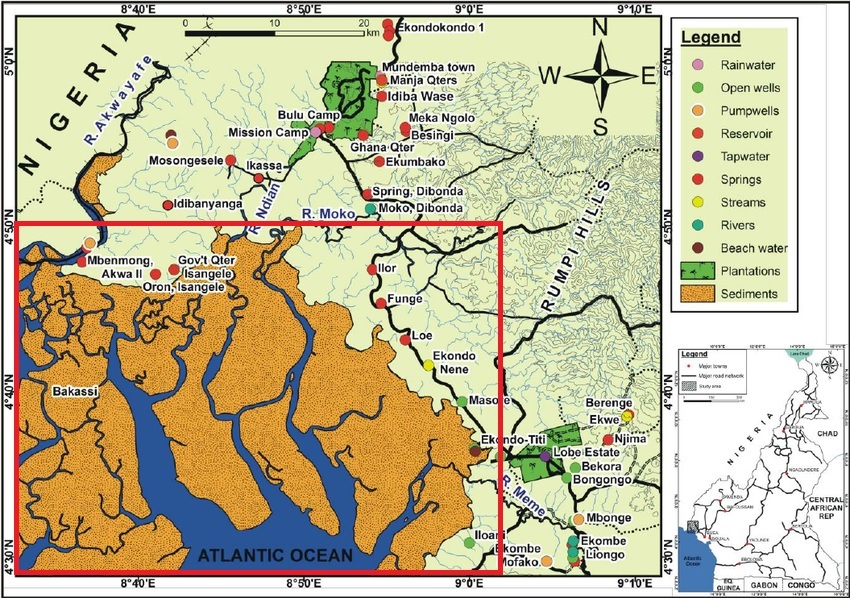
Marine ecosystem conservation programme will focus on the Bakassi marine ecosystem. It is a trans-boundary site between Cameroon and Nigeria. It is located in the Bakassi Peninsular of Ndian Division, South West Region of Cameroon at the edge of the Gulf of Guinea. The area is surrounded by five divisions (Kombo Abedimo, Kombo Itindi, Isangele, Bamusso and Idabato). It has an estimated population of 150,000 and 300,000 people. The primary productive sectors of the local economy are agriculture (commercial and subsistence farming), fishing, and collection of non-timber forest products (NTFPs), hunting, livestock rearing and forestry. The main activity of the site will be focus on the creation and management of the Proposed Ndongere Marine National Park.
| Rio Del Rey Estuary |
Mangrove Ecosystem Conservation Programme
The mangrove ecosystems conservation programme will focus on the South West Coast of Cameroon and will target the following areas.
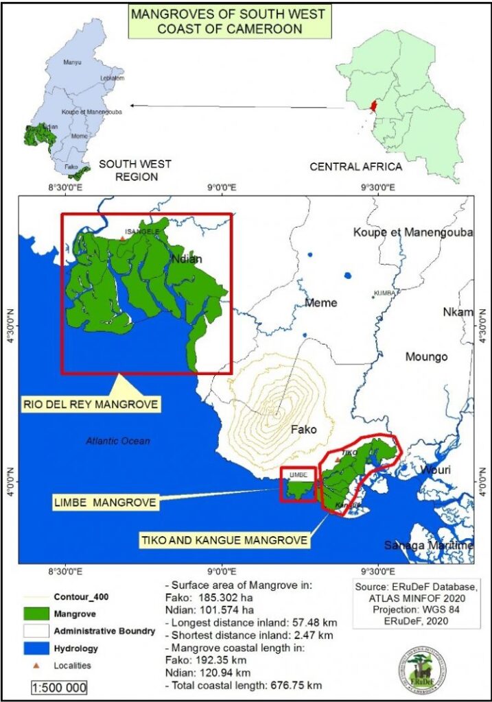
- The Tiko and Limbe Mangrove area which forms part of the mangroves of the Cameroon Estuary. The mangroves are located in Fako Division, about 30 and 35 km South of Buea (Feka and Mario, 2008), the administrative capital of the South West Region. It has a total mangrove area of about 19,000 ha (Feka and Mario, 2008).
- The Rio del Rey mangroves found in Ndian division along the border with Nigeria. The Rio del Rey mangrove occupies an area of about 100,000 ha and constitutes half of the total 200,000 ha of mangrove forest ecosystems in Cameroon (UNEP, 2007; Ajonina 2008). It occupies the seven subdivisions in Ndian Division. The subdivisions are Mundemba, Ekondo Titi, Bamusso, Isangele, Kombo Abedimo, Kombo Itindi, and Idabato (Figure 2).
Inland Lakes Conservation Programme
It will focus on the following lakes and Reservoir
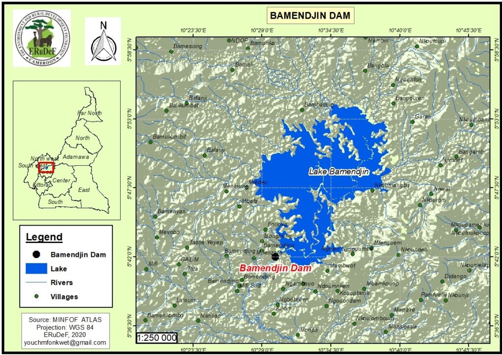
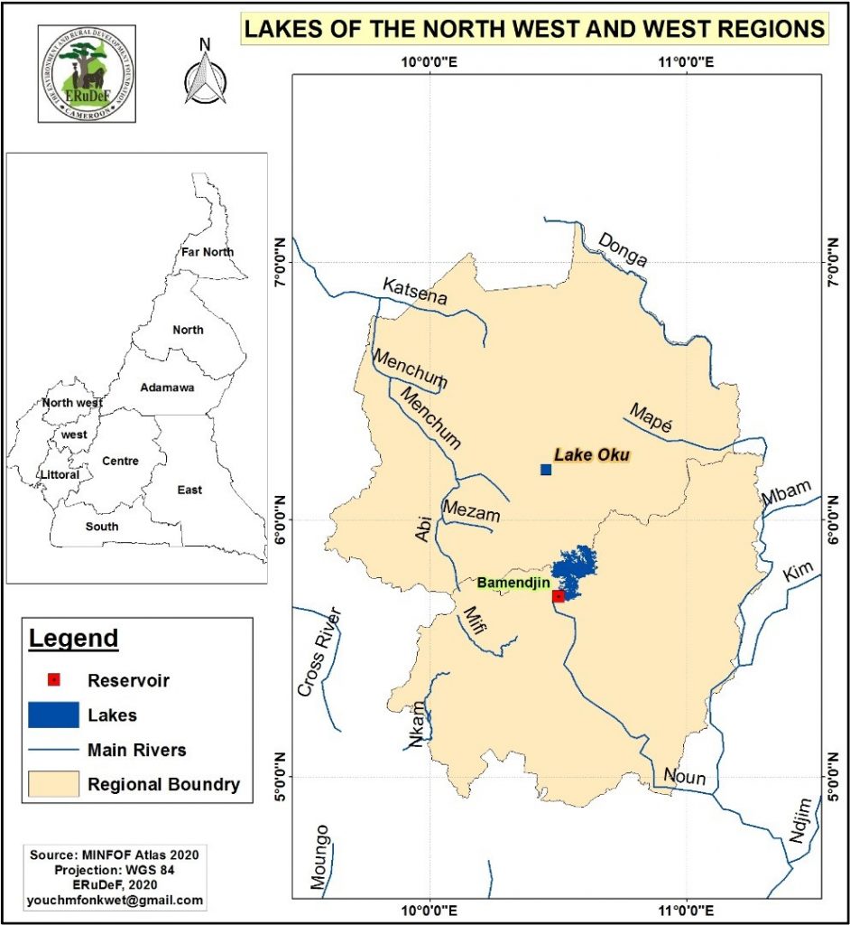
Bamendjing Lake and Reservoir
Bamendjing
Reservoir is located in the Northwest and West Regions of Cameroon. The
reservoir is found within five subdivisions. These subdivisions includes:
Balikumbat, Bangourain, Galim, kouoptamo, and Ndop. The estimate terrain
elevation above sea level is 1150 metres. Constructed in the Bamendjin village
of Galim Sub-division, the dam mostly affects the areas of Foumbot, Foumban,
Galim and Ndop in the Bamboutous, Noun and Ngoketunjia Divisions in the West
and Northwest Regions, respectively. All these regions are located within the
Noun River drainage basin.
Following
the dam construction, environmental and land security has been a major issue,
as evidenced by farmer-herder and herder-herder conflicts over land and
inter-tribal wars over land use resources. The Noun River watershed has been
highly degraded upstream by displaced farmers carrying out intensive
agro-pastoral activities, deforestation causing severe soil erosion, and
environmental pollution (Kometa and Ebot, 2012). This situation is compounded
by a drop in the water table and insufficient potable spring water from nearby
watersheds.
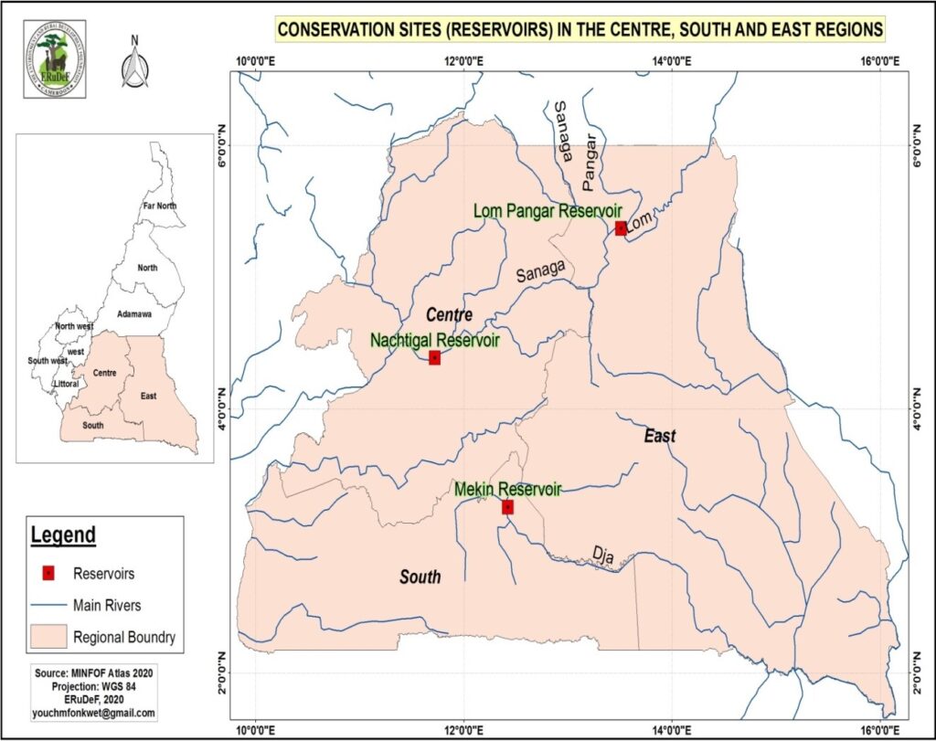
- Lom Panga Reservoir
Lom Pangar is an embankment dam with a center gravity dam section currently under construction on the Lom River about 88 kilometres north of Bertoua in the East Region of Cameroon. It is located about 4 kilometres downstream of the Lom River’s confluence with the Pangar River and about 13 kilometres upstream of where the Lom joins the Sanaga River. The study area is located in the forest-savannah transition zone. Phyto geographically, this zone is entirely within the semi-deciduous rain forest.
- Nachtigal Reservoir
Nachtigal Reservoir is situated on the Sanaga River near Nachtigal falls and is located approximately 65km from Yaoundé, the capital city of Cameroon. The project area is located in the semi-deciduous Guinea-Congolese rainforest. It is a transition zone between forest and savannah. The vegetation in the area of the facilities is chiefly characterized by forest galleries along the river and shrubby savannah maintained as a result of bush fires, one of the main factors determining the regression of forest stands inventoried in the zone. Disruptions caused by logging are visible along the shoreline. The strips of forest found here are cleared for agricultural purposes. Inventories conducted in the impacted zones (construction areas, flooded zone) revealed a total of 366 plant species, of which 15 are tree species with commercial value and nearly 155 species, not endemic to the study area, are used locally in traditional medicines and other traditional uses (non-timber forest products). Several protected bird species (Cameroonian wildlife legislation) are present in the area. About 34 wildlife and 122 bird species have recorded in the area. About 65 fish species belonging to 16 families, of which 9 are indeterminate or new to science and 24 species endemic to the Sanaga. However, literature review shows that 21 additional species were recorded in the area, although they have not been inventoried by catches. With the combination of both sources of information, there are up to 86 species (from 18 families) reported in the area.
Mekin Reservoir
It
is Located in the South Region of Cameroon. The Mekin hydroelectric
power plant is in the Dja and Lobo Division, Southern Cameroon.
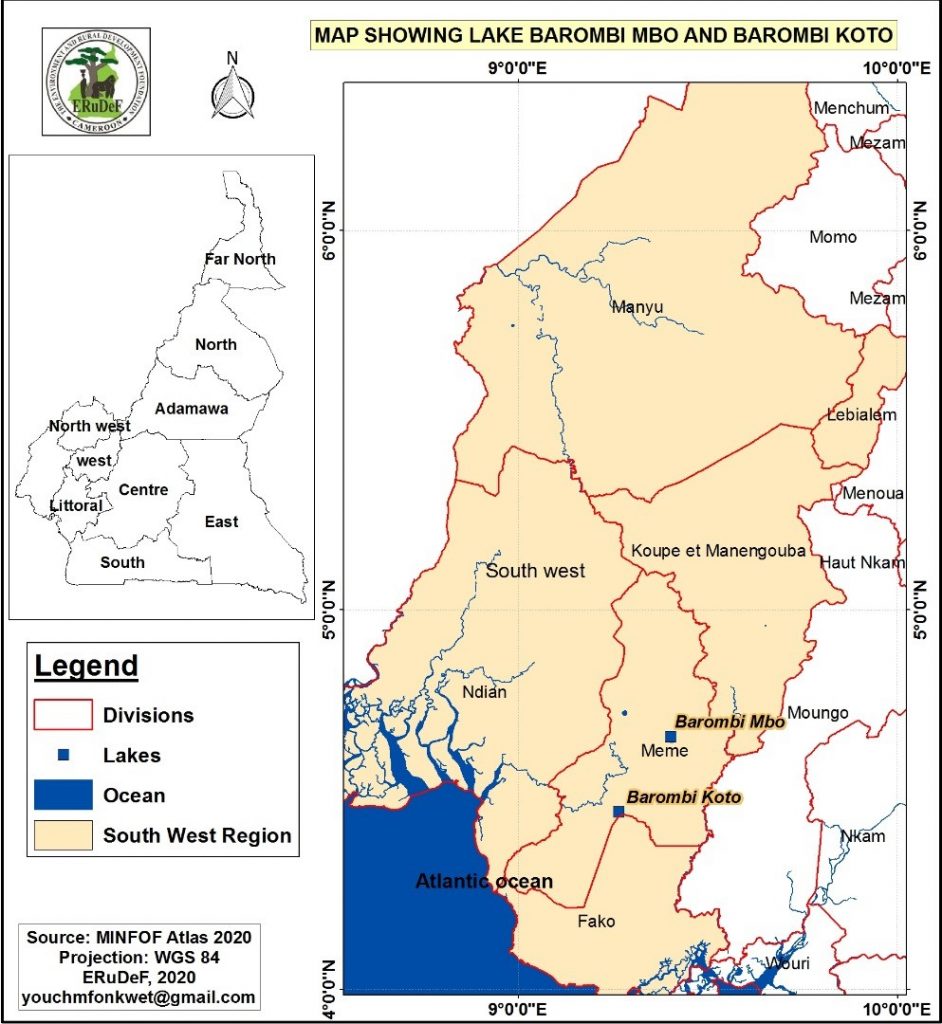
- Lake Barombi Mbo
Lake Barombi Mbo or Barombi-ma-Mbu is a lake near Kumba in the Southwest Region of Cameroon. It is located in the Cameroon volcanic chain, and is the largest volcanic lake in this region. It is one of the oldest radiocarbon-dated lakes in Africa, with the youngest lava flow in it being about one million years old.
- Lake Barombi Kotto
Lake Barombi Koto, also known as Lake Barombi Kotto or Lake
Barombi-ba-Kotto, is a small lake in the volcanic
chain in the Southwest Region of Cameroon. It is a volcanic
lake with a diameter of about 1.2 km. There
is a small island in the middle, which is densely inhabited by the Barombi, a tribe of fishers.
- Lake Oku
Lake Oku is a crater
lake on the Bamenda
Plateau in the Northwest
Region of Cameroon.
It is located at 2,227 metres (7,306 ft) on Mount Oku,
and is completely surrounded by cloud forest. Lake
Oku is one of the last pristine high elevation Crater Lake ecosystems in
Cameroon. It is the only known habitat of the ‘Critically Endangered’ Lake Oku
Clawed Frog, and the second known locality for the Vulnerable, rare plant Isoetes biafrana. Threats affecting this lake
include: introduction of fish and other exotic organisms (including pathogens);
sedimentation to the lake through degradation of the adjacent forest
(particularly through livestock and building construction); pollution of the
lake through littering by visitors and run-off of chemicals from adjacent road;
unregulated visits to the lake.
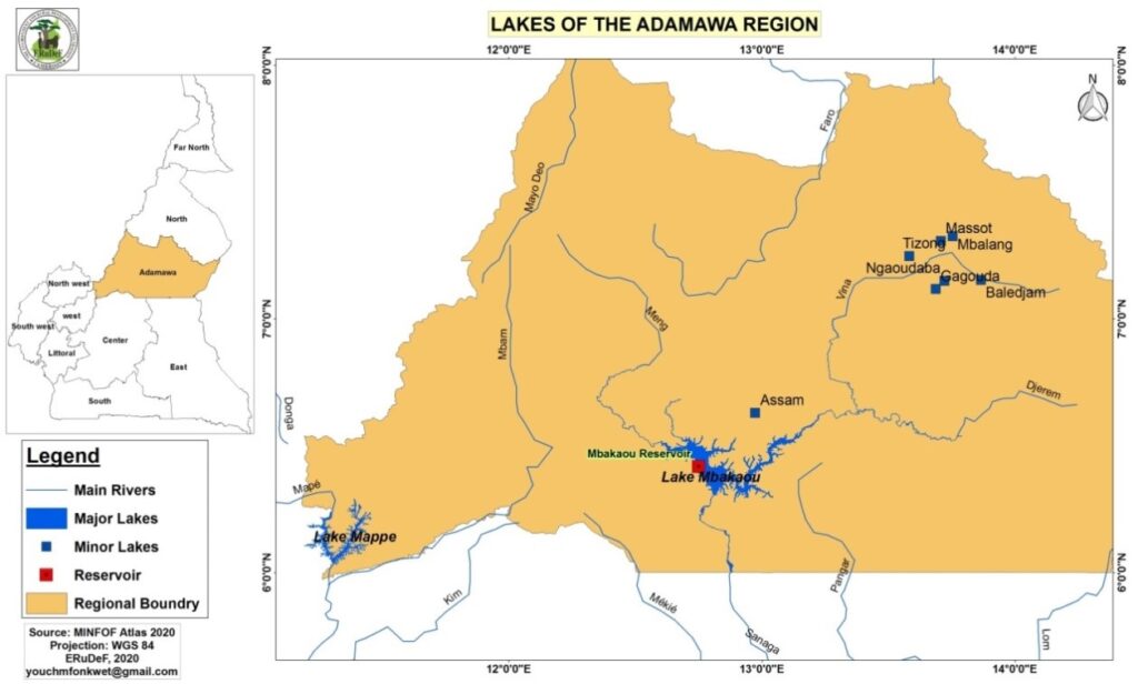
- Lake Mbakaou and Reservoir in Adamawa Region
The Mbakaou Reservoir is located on the
Djerem River, in the town of Mbakaou in the Department of Djérem (Adamawa
region). It is intended to regulate the level of the Djerem, a tributary or
upper part of the Sanaga River.
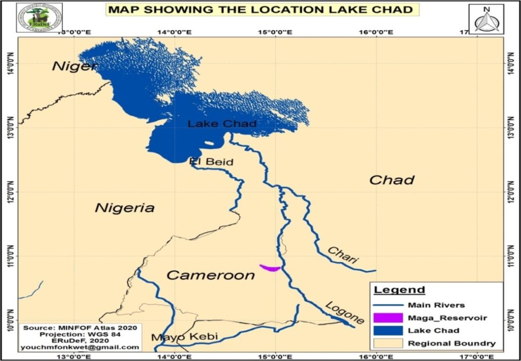
- Lake Chad
Lake Chad is a historically large, shallow lake in Africa. The Freshwater lake is located in the Sahelian zone of West-central Africa. It is located in the
interior basin which used to be occupied by a much larger ancient sea sometimes
called Mega Chad. The lake is historically ranked as one of the largest lakes
in Africa. However, its surface area varies by season as well as from year to
year. Lake Chad is mainly in the far west of Chad, bordering on northeastern Nigeria. The Chari
River, fed by its
tributary the Logone,
provides over 90% of the lake’s water, with a small amount coming from the Yobe
River in Nigeria/Niger.
Rivers Systems Restoration programme
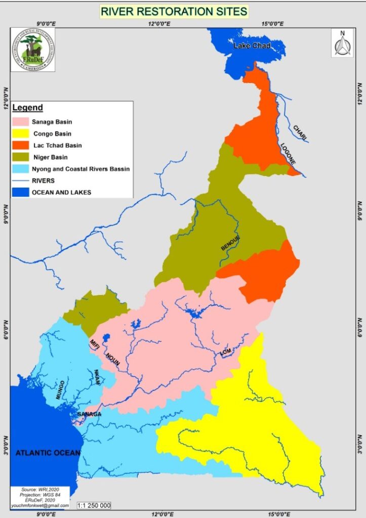
The River systems restoration programme will target the following river systems in Cameroon.
- Mungo River
The Mungo River is located in the South West Region. It has a catchment area of 4,200 square kilometres. The river is 150 kilometres long, rising in the Rumpi Hills and swelled by tributaries from Mount Kupe and the Bakossi mountains.
- Nkam River
The Nkam River rises in the Western High Plateau in the West Region of Cameroon, and joins the Makombé River to become the Wouri River. It is known to tourists for the spectacular Chutes d’Ekom, an 80 metres (260 ft) high waterfall about 30 kilometres (19 mi) from Bafang. To the south of the town of Dschang, the Santchou Faunal Reserve lies to the east of the river.
- Sanaga River
The Sanaga River is a river of East Region, Centre Region and Littoral Region of Cameroon. Its length is about 600 kilometres. The Sanaga River has its Source at the Adamawa Plateau. It is formed by the confluence of the Djérem River and Lom River in the north of the East Region. Apart from those originating rivers, its main tributary is the Mbam River.
- Benue River
It rises in the Adamawa Plateau of northern Cameroon, from where it flows west, and through the town of Garoua and Lagdo Reservoir, into Nigeria south of the Mandara mountains, and through Jimeta, Ibi and Makurdi before meeting the Niger River at Lokoja.
- Logone River
The Logone River is a major tributary of the Chari River. The Logone’s sources are located in the western Central African Republic, northern Cameroon, and southern Chad. It has two major tributaries. The Pendé River (Eastern Logone) in the prefecture Ouham-Pendé in the Central African Republic and the Mbéré River (Western Logone) at the east of Cameroon.[2] Many swamps and wetlands surround the river.
- The Chari River
It is a 1,400 kilometres (870 mi) long river, flowing in Central Africa. It is Lake Chad‘s main source of water. The Chari River flows from the Central African Republic through Chad into Lake Chad, following the Cameroon border from N’Djamena, where it is joined by its western and principal tributary, the Logone River.
Key Activities
Conservation
The key activities include:
- Creation of the proposed Ndongere Marine National Park in the gulf of Guinea
- Management of the Proposed Ndongere Marine National Park in the gulf of Guinea
- Creation of 7 mangrove community forest (Tiko, Limbe, Bamusso, Isangele, Kombo itindi, Kombo Abedimo, Idabato)
- Management of 7 mangrove community forests
- Promote Education for Sustainable Development in community around the Park
- Support law enforcement in the Ndongere Marine National Park
- Support ecotourism development in the Ndongere Marine National Park
- Support continues Research and Bio monitoring in the Ndongere Marine National Park
Restoration of Degraded Ecosystems
The key activities include:
- Establishment and management of mangrove nurseries
- Mapping of Degraded mangrove areas and riparian forests
- Restoration of degraded mangrove forests (Tiko, Limbe and Rio Del Rey mangroves)
- Restoration of degraded inland lakes ecosystems (Barombi Mbo, Barombi Kotto, Lake Oku, Bamendjin Reservoir, Lom Pangar Reservoir, Nactigal Reservoir, Mekin Reservoir, Lake Mbakaou and Lake Chad)
- Restoration of degraded River ecosystems (Nkam River, Mungo River, Sanaga River, Benoue River, Logone and Chari River).
Support Local Economic Development
Key activities include:
- Mobilization and sensitization of local communities in the target freshwater and marine landscapes
- Promotion of aquaculture development
- Promotion of sustainable agriculture
- Promotion of cottage Industry
Support Sustainable Finance Development
Key activities:
- Support the development of cooperatives and Microfinance institutions
- Creation of Micro finance scheme called the Biodiversity Community Trust (BCT) a savings and loans scheme
- Establishment of cooperative enterprises
- Creation and legalization of the Forest Protection Fund
Gender Mainstreaming
Key activities:
- Strengthened women capacity on freshwater and marine conservation
- Empowering of women financially
Applied Research
Key activities:
- Training of local stakeholders to conduct research and biomonitoring in freshwater and marine ecosystems.
- Conduct annual surveys in collaboration with local stakeholders on threatened species (fish, amphibians, reptiles, birds, and mammals).
- Conduct annual surveys on the structures and ecology of mangroves and other threaten flora species.
- Support local community in collecting and reporting monthly data of species in the target freshwater and marine landscapes
Promote Effective Landscape Governance
Key Activities:
- Create and support Stakeholder forum/platform
- Training of Eco-guards and community guides/rangers
- Strengthened local communities rangers on existing policies and Legal framework
Problem Analysis
Cameroon rich species abundance biodiversity has made it one of the world’s biodiversity hotspots. With a total freshwater landmass of 3960 km2 (MINEPIA 1997) and a coastline that stretches for about 360 km (FAO, 1987), Cameroon host about 600 fresh and saline water fishes (Brummett, 2007) as well as species of crustaceans, mollusks, amphibians, reptiles, mammals and birds. However, there is increasing loss of biodiversity in Cameroon’s freshwater and marine ecosystems. The major causes are habitat destruction through agricultural expansion into coastal forest and riparian forest areas, widespread harvesting of mangroves and other forest tree species, the over-exploitation of selected fish species to supply trans-boundary markets, and the frequent use of dynamite, cyanide, and other illegal gears in fishing, Pollution, mining activities, dam construction and the introduction of invasive species. This is mainly due to the lack of integrated ecosystem services management plan, lack of law enforcement, education and training. These causes to biodiversity loss need immediate intervention without which the resulting consequences will be the rapid degradation of the freshwater and marine resource base, the rapid expansion of the agricultural frontier, loss of threatened species of fauna and flora with the livelihood of the local populations threatened. However, if these causes are given maximum attention, it will ensure the recovery of degraded mangrove and riparian forests, the adoption of sustainable practices by most resource users, the development and implementation of an integrated ecosystem services management plan, the effective management and conservation of freshwater and marine resources and will also improve on the livelihood of the local populations.
Methods of Implementation
The Freshwater and marine programme will be implemented in a collaborative manner involving all stakeholders directly or indirectly interested in the natural resources of the targets freshwater and marine ecosystems. Using a participatory approach will help all interested groups to participate in the development of one vision for the sustainable use and management of the ecosystems.
Creation of the proposed Ndongere national park and mangrove community forests will be carried out through a series of biological and socioeconomic surveys and stakeholder’s consultation meetings. A management plan will be prepared on the basis of biophysical and socioeconomic data and the outcomes of consultation meetings.
Forest restoration will be carried out through the participatory management of nurseries and planting of seedlings. The local communities will be trained on nurseries management through training and sensitization workshops.
Local economic activities will be generated through mobilization, surveys, training and sensitization of local communities.
Sustainable finance development will be promoted and supported through the creation of cooperatives, cooperatives enterprises and Forest Protection Fund. The cooperatives will be created through need assessment surveys, mobilization of communities, training and sensitizations.
Gender mainstreaming will involve a series of mobilization, training and sensitization meetings.
Applied Research will be conduct through appropriate scientific research methods.
A participatory monitoring and evaluation system will be established to monitor progress in the implementation of the projects.
Outputs
The Freshwater and Marine Landscape Conservation Programme will achieve the following outputs:
- The Proposed Ndongere Marine National Park and 7 Mangrove Community Forests will be created and managed.
- At least 1 million mangrove trees planted to restore degraded mangrove forests and 2 million indigenous trees planted to restore degraded riparian forests.
- Income generating activities such as cottage industry, aquaculture, and sustainable agriculture initiated with technical and financial support provided to at least 10000 local people within the targets freshwater and marine landscapes.
- At least 15 small size cooperatives, microfinance institutions and cooperative enterprises established in communities around the targets freshwater and marine ecosystems.
- At least 10000 women enhanced and involve in the conservation of freshwater and marine ecosystem
- Data base of the threaten species of freshwater and marine ecosystem established and published in journals and ERuDeF website
- At least 10000 local people including government officials, Eco guards, and field guides/rangers strengthened and supported.
Outcome
- Effective management and protection of marine and mangrove ecosystems through the management of Marine protected area and mangrove community forests.
- Degraded freshwater and mangrove forest ecosystems restored and protected
- Increased income of at least 10000 local population in the targets freshwater and marine landscapes
- Effective running and management at least 15 Cooperatives, Microfinance institutions and cooperative enterprises for local development in the landscapes.
- An enhance community of at least 10000 women actively involved and participating in the conservation of freshwater and marine ecosystems.
- Publication of research papers in journals, monthly articles published in the ERuDeF E-newsletter, ERuDeF Green Vision newspaper and ERuDeF Conservation Impact Magazine.
- Eco-guards and the local community actively involved in enforcing wildlife and forestry law of Cameroon as well as other treaties ratified by Cameroon.
Programme Governance
The Environment and Rural Development foundation (ERuDeF) is the main executing agency for this Freshwater and Marine Programme. ERuDeF is an award-winning non-profit Cameroonian conservation organization established in 1999 with the mission to conserve biodiversity and protect fragile Ecosystems through training, research, education, and community engagement.
ERuDeF has put in place an implementation team that comprise of the following persons:
- ERuDeF Vice President in Charge of Science
- National Programme Manager
- Landscape Programme Coordinator
- Budget and Finance Officer
- Accountant
- Monitoring And Evaluation Officer
Security and Risks Analysis
Potential risks that might change the programme objectives and outcomes will be identified throughout the programme life cycle. However, some risks which might impact the programme identified from risk repository, checklist analysis and project status are categorized into
- Project management: These include inadequate planning, schedule, communication gaps, poor estimations etc. the probability of these risks occurring is very low and measures will be taken to eliminate it completely.
- Political: these include lack of collaboration of government officials, chiefs, and elite and other important stakeholders. The probability here can be very high but a response plan will be put in place to eliminate or lower occurrence.
- Organizational: these include limited logistics, resources and budget to run the programme. The probability of occurrence of these risks is low as a sustainability plan will be developed.
- Technical: These include technology, performance base and quality delivery. The probability of risk occurrence is low as an experienced implementation team will be put in place.
- Physical risks: This includes external hazards such as terrorism and disease outbreak which might occur during project implementation leading to a halt in the project.
Monitoring, Evaluation and Impact Learning
Monitoring and evaluation will be performed as an ongoing management and learning activity, supported by periodic external independent reviews. A Monitoring, Evaluation and Impact Learning plan will be developed to assist the management of the programme as well as an instrument to measure progress by the partners. Outputs of the programme will be measured using monitoring procedures. Activities are tracked through contracts and reports and measured against outputs planned on an annual work planning and project cycle basis. The outputs are specified in the Log Frame matrix and in the annual work plans. They will be reported against in the regular progress reports.
Sustainability of the Freshwater and Marine Landscape Programme
This sustainability plan will focus on community sustainability, financial sustainability and organizational sustainability.
For community sustainability, the programme will ensure that local people feels like the programme is theirs. This is to ensure the success of the programme as it is very clear that without the support of the community, many projects have no chance of survival. The local communities (beneficiaries) will be involved in planning and implementation of the programme at all stages.
For financial and organizational sustainability, the programme will secure external and internal funding sources. The external funding sources will be grants from some of the partners ERuDeF has been working with such as the Global Environment Facility (GEF), Sustained 365 Australia, Zoological Society of London UK, African Conservation Foundation UK and International Conservation Fund of Canada.
The internal funding sources will be the development of an ecotourism programme that will bring in international volunteers. They will also be the limited exploitation of natural resource like mangrove, fish for cottage industries. They will also be value chain development of the Non-Timber Forest Products and their integration into the Access and Benefit Sharing Initiative.
Global partnership programme
A successful conservation and development programme requires partnerships between governments, the private sector and civil society. These inclusive partnerships built upon principles and values, a shared vision, and shared goals that place people and the planet at the centre, are needed at the global, regional, national and local level. The Environment and Rural development foundation (ERuDeF) has been working with a wide range of partners and will continue to build on this partnership to support the conservation of freshwater and marine ecosystems. This partnership include a memorandum of understanding with government ministries such the Ministry of Forestry and Wildlife (MINFOF), Ministry of Environment, Nature Protection and sustainable development (MINEPDED). ERuDeF will also create new partnership with the United Nations Environment programme, Global Environment Facility, Total Foundation, Oceana, Pew Charitable Trust, Conservation Foundation, Mangroves Foundation and The Global Nature Fund for the conservation of freshwater and marine ecosystems.
Dissemination of Results
Results of the projects will be communicated and disseminated to various stakeholders through the various means:
- Project results will be presented in the forms of flyers, reports, and magazine and distributed to all the stakeholders.
- Sharing of project results through social media platforms
- Summarizing findings in progress reports for funders
- Disseminating results on the ERuDeF website, E – newsletter and Green vision newspaper
- Discussing project activities and results on the local radio and TV programmes
- Publishing information in Journal
